Frequently Asked Questions
Assistant software
- Where can I find my serial number?
- How do I know which percentage to use?
- What is the difference in the percentages at the bottom? There are some that say "Unweighted" and some that say "Effect". At the bottom of the Actual Unshaded % column I get an unweighted yearly average (89.19%) and at the bottom of column 2 I get an "Effect:92.41%". I don't understand the difference between these 2 totals. Naturally, I would like to use the higher one for rebate purposes but this column displays sun hours and I need percentages.
- Do I have to trace on the diagram before I take the photo?
- Does the Assistant software account for magnetic declination?
- How do I know what derate to use?
- How do I take the photo of the Pathfinder for the Assistant software?
- How is the Azimuth/Altitude data calculated on the Summary Report page?
- How many analyses do I need to do for each array?
- How much of the photo should be cropped at the "Cropping Image" page?
- What is the "Array Configuration" page for?
- What photo goes at the "Array Configuration" page?
- Why can't I change my azimuth? I don't see a place to change it.
- Why doesn't the shading in my photo seem to match the tracing at the bottom of the report?
- Why is the software asking for a "challenge code"?
- What information is included in the local weather data?
Pathfinder
- Do I need to take more than one reading to get percent of shading?
- Does it matter what time of day I make the tracing?
- Does it matter where I stand when I take the photo?
- How can I calculate for shading for a future roof-top site?
- How do I adjust for magnetic declination?
Sunpath Diagrams
- Do I need a different diagram if I am on a flat roof?
- Do the Solar Pathfinder diagrams account for Daylight Savings Time or real solar hours? Or "why doesn't the time of day on the Solar Pathfinder match my watch?"
- What is the difference between the horizontal and vertical ("south-facing" for the northern hemisphere) diagrams?
Q. Where can I find my serial number?
A. As of August 2008, the serial number is on a label on the back of the envelope that the Assistant software came in. For download orders, the serial number will be emailed to you upon completion of the order. The serial number is case sensitive. If you have misplaced your serial number, go to the Lost your serial number? page on our site. Follow the directions and your serial number will be automatically emailed to you.
filed in Assistant softwareQ. How do I know which percentage to use?
A. If you are reporting to an agency for rebates, etc., you need to check with them to see what formula they are requiring. See the definitions for each of the columns at the description window under "Options" / "Report Columns".
filed in Assistant softwareQ. What is the difference in the percentages at the bottom? There are some that say "Unweighted" and some that say "Effect". At the bottom of the Actual Unshaded % column I get an unweighted yearly average (89.19%) and at the bottom of column 2 I get an "Effect:92.41%". I don't understand the difference between these 2 totals. Naturally, I would like to use the higher one for rebate purposes but this column displays sun hours and I need percentages.
A. The "unweighted" columns mean that each month is treated equally. It is what you would get when you averaged the numbers equally on the diagrams. The problem with using that number is that November, December, or January is never "worth" as much as May, June, or July in radiation (in the Northern hemisphere). Therefore 100 percent of January may be equal in radiation to 80 of June, etc. As a general rule, most rebate reporting agencies are looking for the Effect % and/or Sun Hours (the higher percentage).
filed in Assistant softwareQ. Do I have to trace on the diagram before I take the photo?
A. No. You will use the software to "trace" the shading onto your photo. The Assistant report will then be your permanent record for the site.
filed in Assistant softwareQ. Does the Assistant software account for magnetic declination?
A. Yes. The software is working with the reflection itself and not the diagram underneath. When you enter the zip code and set the level and compass for magnetic north/south, the Assistant software knows how much the image needs to be rotated for declination. If the shading in the photo seen at the bottom left of the report doesn’t seem to match the tracing on the diagram on the bottom right of the report, then you accidentally set your declination improperly on the Pathfinder unit itself. The Assistant software will automatically account for declination based on the zip code or latitude/longitude you entered.
filed in Assistant softwareQ. How do I know what derate to use?
A. If you are reporting to an agency for rebates, you need to check with them to see what derate they are requiring. Some states, such as Wisconsin have a set derate of .8. California derates the system for rebate purposes using only the inverter derate. Please check with your reporting agency. If you are using the software to size a system, we recommend that you use the calculate derate option for more accuracy.
filed in Assistant softwareQ. How do I take the photo of the Pathfinder for the Assistant software?
A. You need to stand on the side of the Pathfinder opposite of the sun so that your reflection will not block any of the sun paths. For the northern hemisphere, that would be the north side. There are 2 guidelines for taking a good picture for the software:
- Fill the viewing area of your camera with the Pathfinder without cropping any of the blue (or green) plastic housing.
- Keep the camera centered above the Pathfinder. The easiest way to check is to make sure that the blue (or green) plastic housing is equi-distant around the lens.
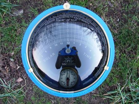
The above is a Great Photo because the unit is centered, fills most of the viewing area and the entire unit is in full view.
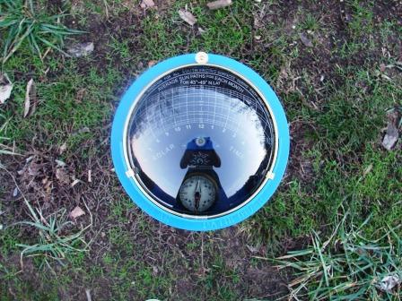
The above is only a Good Photo because the unit should fill more of the viewing area (too far).
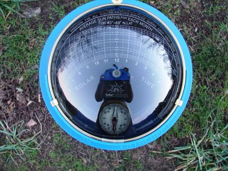
The above is a Bad Photo because plastic housing is cropped off. You want to fill the viewing area of your camera with the Pathfinder without cropping any of the blue (or green) plastic housing.
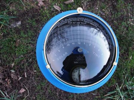
The above is a Bad Photo because the camera is not centered above the Pathfinder. The easiest way to check is to make sure that the blue (or green) plastic housing is equi-distant around the lens.
filed in Assistant softwareQ. How is the Azimuth/Altitude data calculated on the Summary Report page?
A. The altitude angles are in reference to the shade outline pictured during the site analysis. The Assistant software calculated the angle to the top of the obstruction (shade) object in the specified compass direction.
The "angle 1" on the Formula page is an example of the meaning of this angle.
filed in Assistant softwareQ. How many analyses do I need to do for each array?
A. If you are reporting to an agency for rebates, you need to check with them to see what they are requiring. Some states only require 2, one at each of the bottom corners. California requires an analysis at "all major corners".
filed in Assistant softwareQ. How much of the photo should be cropped at the "Cropping Image" page?
A. "Click and drag" each of the 4 handles at the sides until the side touches the outside edge of the plastic housing of the dome section in the photo. See the example to the left of the page in the program.
filed in Assistant softwareQ. What is the "Array Configuration" page for?
A. The Array Configuration page logs the exact place where each of the analysis was taken. The purpose of this page is to enable anyone coming after you (an inspector, etc.) to see exactly where the analysis was taken and duplicate your report, if needed. If you are working on a roof mount, you take a picture of the roof and import it here. You can then mark on the photo how many analyzes are included in the report. You can insert numbers that will correspond to the different tracings/photos of the dome you will include in your report. This System Picture Layout page is valuable for inspectors or anyone wanting to "duplicate" or verify your report. See sample below:
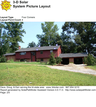
The above is a Sample Page of report of System Picture Layout. This array configuration is for a "four-corner" analysis where the software will average the 4 pictures taken at the 4 places indicated.
filed in Assistant softwareQ. What photo goes at the "Array Configuration" page?
A. The Array Configuration page allows you to enter a photo of the roof where the future arrays will be installed. Once you have loaded a photo of the roof, you may choose how many analyses you will be making on the roof top: one, four, or a custom number. The numbers below your photo can then be dragged onto the photo to show where you took the analysis for the array. These numbers will correspond with the different tracings/photos of the dome you will import in the next section of the program.
filed in Assistant softwareQ. Why can't I change my azimuth? I don't see a place to change it.
A. More than likely the settings on your monitor have been altered, making the font/text too large (shoving part of the analysis settings off the page where you can't see them). Go to: Start / Control Panel / Display / "Settings" tab — both the screen resolution and the color quality should be at their highest settings. Hit "Apply"; then "OK".
filed in Assistant softwareQ. Why doesn't the shading in my photo seem to match the tracing at the bottom of the report?
A. The Assistant software will automatically account for declination based on the zip code or latitude/longitude you entered. If the shading in the photo seen at the bottom left of the report doesn't seem to match the tracing on the diagram on the bottom right of the report, then you accidentally set your declination improperly on the Pathfinder unit itself.
filed in Assistant softwareQ. Why is the software asking for a "challenge code"?
A. The "challenge code" is our "back-up" system for licensing. You need to have internet access during the initial licensing process. If you are on the internet and are still getting this message, you are probably on a network and will need to get your IT person to allow the software have temporary access to the internet for registration.
filed in Assistant softwareQ. What information is included in the local weather data?
A. 1) We use TMY2 data which is a statistical data base of "typical" hourly weather data for an entire year. The "typical year" represents data gleaned from 30 years of weather data. It implicitly includes cloud cover data as part of the radiation data.
2) The Solar Pathfinder Assistant uses the following information from the hourly data:
- Direct solar radiation
- Diffuse solar radiation
- Snow cover
- Ambient Dry Bulb Temperature (Solar Hot Water only)
3) More information about TMY2 can be found here: http://rredc.nrel.gov/solar/old_data/nsrdb/tmy2/
4) Information about the EnergyPlus format can be found here: http://apps1.eere.energy.gov/buildings/energyplus/weatherdata_format_def.cfm
filed in Assistant softwareQ. Do I need to take more than one reading to get percent of shading?
A. If the analysis is for a smaller array, one reading may be sufficient. If you are doing analysis for rebates, you need to contact your local agency to find out their requirements. Some require only one reading, some require readings at the bottom two corners of the array, some require readings taken at all the major corners. The Solar Pathfinder Assistant software automatically averages multiple analyses.
filed in PathfinderQ. Does it matter what time of day I make the tracing?
A. The Solar Pathfinder is designed to give a full year’s worth of solar radiation data in an instant. It does not matter what time of day or day of year you take your analysis. It is easier to take the reading on somewhat cloudy or overcast days to avoid the sun’s glare.
filed in PathfinderQ. Does it matter where I stand when I take the photo?
A. Yes, stand directly over the center of the dome with the camera within 12-18 inches of the top. The photo should show an even amount of the blue rim around the dome section.
filed in PathfinderQ. How can I calculate for shading for a future roof-top site?
A. The most accurate analysis will always be taken at the height and location of the array. When accessibility is not an option, you can manually calculate solar access. Because distance to each shading object makes a difference, the calculations can be somewhat time-consuming. Instructions, diagrams, and a free downloadable spreadsheet are available on the Formulas page of our site. We are hoping to include this feature in our software sometime in the future.
filed in PathfinderQ. How do I adjust for magnetic declination?
A. Gently pull out the brass Magnetic Declination Tab located by the compass 1/4". This will allow the center triangle and black disk to easily pivot. The “number line” on the perimeter of the diagram is for magnetic declination adjustment. The numbers to the left of “0” are “west of north” or negative numbers. The numbers to the right of “0” are “east of north” or positive numbers.
- Rotate the sunpath diagram on the central pivot counterclockwise for declinations to east of north (positive numbers). This would be for the western continental US as well as other places around the world.
- Rotate the sunpath diagram on the central pivot clockwise for declinations to west of north (negative numbers). This would be for the eastern continental US as well as other places around the world.
After you have correctly adjusted for magnetic declination, gently push the brass Magnetic Declination Tab back in toward the compass. This “locks” the diagram into place. The “noon” hour has now been adjusted to face “true south”.
For a definition of magnetic declination, more detailed instructions and maps concerning magnetic declination, see the manual or the Magnetic Declination page on our site.
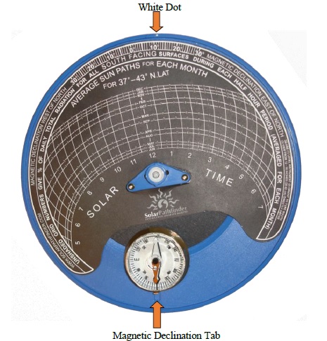
This picture shows the PF with magnetic declination set at +11 degrees. This would be correct for some parts of the western continental US.
filed in PathfinderQ. Do I need a different diagram if I am on a flat roof?
A. If you are using the Assistant software, it will automatically calculate for whatever tilt angle you enter. If you are manually calculating using only the Solar Pathfinder (without the software), you will need the horizontal diagram to give you the correct percentage of solar radiation.
filed in Sunpath DiagramsQ. Do the Solar Pathfinder diagrams account for Daylight Savings Time or real solar hours? Or "why doesn't the time of day on the Solar Pathfinder match my watch?"
A. The sunpath diagrams show real solar time and will not necessarily line up with "clock time". Adjustments need to be made for Daylight Savings Time, what month it is, where you are in the time zone itself, etc. A detailed description of how to calculate the difference between "solar time" and "clock time" is given in the Solar Pathfinder manual.
filed in Sunpath DiagramsQ. What is the difference between the horizontal and vertical ("south-facing" for the northern hemisphere) diagrams?
A. The horizontal diagrams are intended for tilts of 0-20 degrees. The vertical ("south-facing" for northern hemisphere) are for tilts of 20-90 degrees. Because the Solar Pathfinder always takes its reading when true south and level, the sun paths for each month and the solar hours on both the horizontal and vertical diagrams are exactly the same for any given latitude. The only difference between the horizontal and vertical diagrams is the tiny numbers written in the half-hour increments. These numbers represent the percentage of solar radiation in each half-hour. The percentages differ slightly based on the tilt angle.
The Solar Pathfinder Assistant software automatically calculates for these differences whether you happen to have the correct diagram in the unit when the picture is taken or not. If you are using the Solar Pathfinder Assistant software, the software will make correct calculations for differences in tilt (and azimuth) no matter what diagram you happen to have in the Solar Pathfinder unit (It makes its calculations based on the tracing.
filed in Sunpath DiagramsAbout Us
 We are proud of the fact that our product was and still is a US product. Read our all-American story


