Magnetic Declination
Many people are surprised to learn that a magnetic compass does not normally point to true north. In fact, over most of the earth it points at some angle east or west of true (geographic) north. The direction in which the compass needle points is referred to as magnetic north, and the angle between magnetic north and the true north direction is called magnetic declination. Other terms used are: "variation", "magnetic variation", or "compass variation."
Magnetic Declination Explained
The magnetic declination does not remain constant in time. Complex fluid currents of the elements iron, nickel, and cobalt flow in the outer core of the earth (the molten metallic region lies from 2800 to 5000 km below the earth's surface) generating a magnetic field. The poles of this field do not coincide with the unchanging true north and south — the axis of rotation of the earth. The change in the magnetic fields is known as secular variation.
Local anomalies originating in the upper mantle, crust, or surface, cause further distortions. Ferromagnetic ore deposits; geological features, particularly of volcanic origin, such as faults and lava beds; topographical features such as ridges, trenches, seamounts, and mountains; ground that has been hit by lightning; cultural features such as power lines, pipes, rails and building; personal (ferrous) man-made items such as a stove, steel watch, or even your belt buckle, frequently induce an error of three to four degrees. If you think there are iron deposits in your area, you will want to check with a local surveyor to make sure you are pretty close on the magnetic declination.
Magnetic Declination Maps
Because of secular variation, declination values are constantly changing. When printed maps were the only way of getting this information, the declination values were somewhat out of date by the time the maps got to the general public. In this computer information age that we live in, you can get current information for your exact location. Some web sites for magnetic declination are listed below. With some of them you can even get "historic" information and future predictions concerning any latitude/longitude by inserting different dates.
Australia
You need to know your latitude and longitude for this site. Scroll down the page and enter your latitude, longitude, altitude, etc. Put a check next to "D" (declination) for the Main Field; Submit Request. Example: for -30° latitude, 138° longitude (date: May 1, 2003), the declination is 7.157° (7.157 degrees). For your purposes, round the number of minutes up or down to a whole number and use that number for the magnetic declination.
Canada
You need to know your latitude and longitude for this site. Click on "Magnetic Declination Calculator (MIRP)"on the left side of the page. Type in the appropriate information and submit. Example: for Vanderhoof, British Columbia (124° longitude; 54° latitude, year 2003) the declination is 21° 24' (21 degrees, 24 minutes). For your purposes, round the number of minutes up or down (60 minutes = 1 degree) and use that number for the magnetic declination.
United States
Put your zip code in the appropriate box and click on the "Get Location" button. The site will automatically write in your exact latitude and longitude. Type in the date etc (current date is the default); click on "Compute Declination" to calculate the magnetic declination. Example: for Linden, TN 37096, the latitude is 35.599784 and the longitude is 87.865582; on May 1, 2003 the magnetic declination is "1° 33' W changing by 0° 6' W/year." It is written in degrees ( ° ) and minutes ( ' ). For your purposes, round the number of minutes up or down (60 minutes = 1 degree) and use that number for the magnetic declination (in the example, you could round off the degrees to 2° West of North (negative side of the number line) and rotate the magnetic declination dial clockwise to -2 degrees).
World
This site has maps of each of the continents. Some of the maps are dated 1990, but should give you an idea of the declination. Check with a local surveyor to get more information.
Other Magnetic Declination Web Sites
Magnetic Declination: Frequently Asked Questions
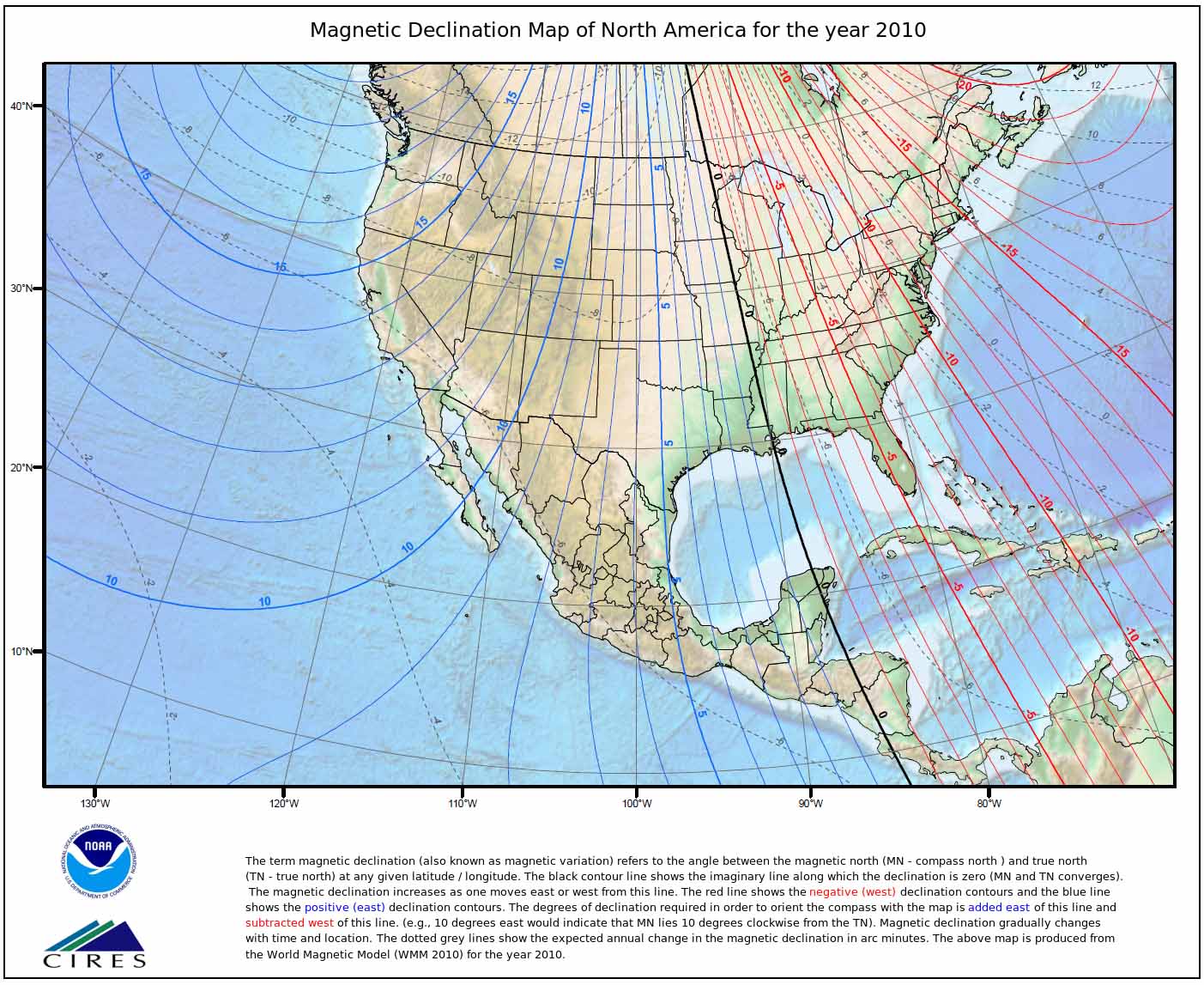
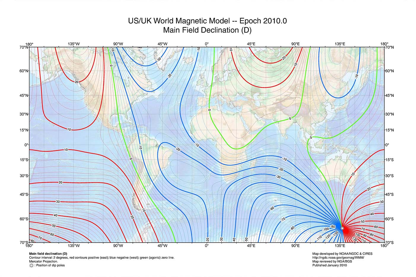
Magnetic Declination Maps
US (click map for larger view)
World (click map for larger view)
Using Magnetic Declination Information on the Solar Pathfinder
The Solar Pathfinder™ has an adjustment feature to compensate for magnetic declination. Gently pull out the brass tab located to the outside of the compass about ¼" to release the magnetic declination dial (the center triangle and black disk). Place the diagram on the black disk and rotate the diagram to make the needed adjustments. Rotate the sunpath diagram on the central pivot counterclockwise for declinations to the east (positive numbers), or clockwise for declinations to the west (negative numbers), until the small white dot on the rim of the base is opposite the appropriate "Magnetic Declination East (or West)." These declination figures are marked on the outside edge of the sunpath diagram. [Think of these figures as part of the "number line" you had back in school — numbers to the left of "0" are considered negative numbers (-); numbers to the right of "0" are considered positive numbers (+)]. See the diagram below that shows the magnetic declination for 11 degrees East of North (+11) This would be for western US. Relock (push in) the brass tab on the outside of the compass. Although this should secure the declination, you should check the declination each time you use it.
![[diagram set to 11 degrees East of North]](/images/spf/11deg_east_of_north.jpg)


